The Province of Batanes is the northernmost and the smallest province of the Philippine Republic, both in terms of population and land area. The provincial capital is Basco.
The province is composed of ten islands (called the Batanes Islands) located about 162 km north of the Luzon mainland in the Luzon Strait and is part of the Cagayan Valley region in Luzon. Of this island group, the largest and most economically important are Itbayat, Batan and Sabtang.
The Batanes Islands are separated from the Babuyan Islands of Cagayan Province by the Balintang Channel and from Taiwan by the Bashi Channel.
The northernmost island of the province, as well as of the Philippines, is Mavudis (Yami) Island. The other islands are Misanga, Ditarem, Siayan, Itbayat, Dinem, Batan, Sabtang, Ivuhos, and Diadekey.
Only Itbayat, Batan, and Sabtang are inhabited. The Batanes is about 190 kilometers south of Taiwan.
People and culture
About 75% of the Ivatans are farmers and fishermen. The rest are employed in the government and services sector. Garlic and cattle are major cash crops. They also plant camote or sweet potato, cassava, gabi or tuber and a unique variety of white uvi. Sugarcane is raised to produce palek, a kind of native wine, and vinegar.
In recent years, fish cath has declined due to the absence of technical know-how to improve the fishermen's catch. Employment opportunities are scarce. Most of the educated Ivatans have migrated to urban centers or have gone abroad.
Distance and bad weather work against its economic growth. Certain commodities like rice, soft drinks, and gasoline carry a 75% to 100% mark-up over Manila retail prices.
Economy
Almost one-half of Batanes are hills and mountains. Batan Island, with a land area of 35 km², is generally mountainous on the north and southeast. It has a basin in the interior. Itbayat Island, which has a total area of 95 km², slopes gradually to the west, being mountainous and hilly along its northern, eastern coast. As for Sabtang, mountains cover the central part of its 41 km² area, making the island slope outward to the coast.
The islands are situated between the vast expanse of the waters of Bashi Channel and Balintang Channel, where the Pacific Ocean, merges with the China Sea. The area is a sealane between the Philippines and Japan, China, Hongkong and Taiwan. It is rich with marine resources, including the rarest sea corals in the world.
The province is hilly and mountainous, with only 1,631.50 hectares or 7.10% of its area level to undulating and 78.20% or 17,994.40 hectares varying in terms from rolling to steep and very steep. Forty two percent (42%) or 9,734.40 hectares are steep to very steep land.
Because of the terrain of the province, drainage is good and prolonged flooding is non-existent. The main island of Batan has the largest share of level and nearly level lands, followed by Itbayat and Sabtang, respectively. Itbayat has gently rolling hills and nearly level areas on semi-plateaus surrounded by continuous massive cliffs rising from 20-70 meters above sea level, with no shorelines. Sabtang on the other hand, has its small flat areas spread sporadically on its coasts, while its interior is dominated by steep mountains and deep canyons. Batan Island and Sabtang have intermittent stretches of sandy beaches and rocky shorelines.
The terrain of the province while picturesque at almost every turn, has limited the potential for expansion of agriculture in an already very small province.
Political
Basco
Itbayat
Ivana
Mahatao
Sabtang
Uyugan
 Municipalities
Batanes lies on a group of islands collectively called Batanes Islands and they are the northernmost islands of the Philippines. They are located between the Babuyan Islands (belonging to Cagayan Province) and Taiwan. The islands are sparsely populated and subject to frequent typhoons.
The three largest islands are Itbayat, Batan, and Sabtang. The northernmost is Mavudis Island.
Climate
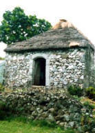
The ancestors of today's Ivatans are descended from Austronesians who migrated to the Batanes Islands 4000 years ago during the Neolithic period. They lived in fortified mountain areas called idjangs and drank sugar-cane wine, or palek. They also used gold as currency and produced a thriving agriculture-based industry. They were also seafarers and boat-builders.
In 1687, a crew of English freebooters headed by William Dampier came with a crew of Hollanders and named the islands in honor of their country's monarchs. Itbayat was named "Orange Isle" in honor of William of Orange, and Batan was named "Grafton Isle" after Henry FitzRoy, 1st Duke of Grafton. Sabtang Isle was named "Monmouth Isle" after the Duke of Monmouth. Capt. Dampier stayed for less than three months, and did not claim the islands for the British crown.
In 1783, the Spanish claimed Batanes as part of the Philippines under the auspices of Governor-General José Basco y Vargas. However, the Ivatan remained on their idjangs, or mountain fortresses. In 1790, Governor Guerrero (

0 件のコメント:
コメントを投稿